Introduction
Due to increasing global insecurity and changing life patterns, presently there exists much technological advancements in terms of systems development, where by each country is endeavoring to ensure its citizens live comfortably and confidently. One of such latest technologies is development of a global position system by the U.S., which engineers have endeavored to improve or better in terms performance and service delivery. This paper will discuss concepts of the global positioning system emphasizing on its use in defense.
Global Positioning System (GPS)
GPS an advanced technological system that uses satellite communication, to give accurate positions, timing and routes to global users. Variations in weather conditions, position or time zones never affect the working of this system, hence at all this times its working is the same. This has made it a good navigational tool for determining time, positions, and locations one is in need of at a specific time. In addition, its use is never limited to the U.S. only, but all individuals can use it globally so long as they have a GPS receiver. The entire system uses solar energy as its main power source, although it sometimes uses battery energy incase a solar eclipse occurs.
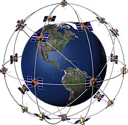
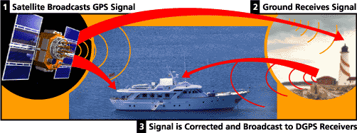
The entire system is comprised of three main sections: GPS receivers, a control and observation centre, and satellites that are in continuous motion. This satellite transmits signals electronically, which individuals with receivers get whenever they want. Information transmitted by this system gives the position of an individual or place in three dimensions; that is it identifies locations in terms of latitude, height above sea level, and longitude (U.S. coast guard Navigation center p.1). To make sure that the system launches correctly and faster information into the orbit, it is reinforced with boosters that increase the ease and speed at which it transmits signals. Its control section has four divisions: shared surface antennas, a parent (master), six monitor centers, and alternate control point. On the other hand, its user interface has integrated mechanisms, which help to change SV signals, hence giving an individual’s exact position, time, and speed. To determine exact positions, a GPS receiver has a mechanism that times signals received for its space satellites. Information received from this satellites include the exact time the satellite sent the signal, the ephemeris (exact orbital information), and the almanac (the overall system condition). After receiving such signals then the receiver calculates the exact transit time, which further helps to calculate exact distances from each satellites. Combination of these two data sets (distance and time), helps the receiver to determine an object or a person’s exact position, using the trilateration. This technology uses the timation satellite technology, which helps to place precise timers in space (Dana p. 1). Although the main user of this system is the military, among civilians, the system finds wide application mostly when identifying locations and positions
Apart from locating positions, this system is useful in other fields, which include commerce, surveying, and in leisure activities such as geo-coaching. In addition, this system is important to the cellular technology, whereby it helps in synchronizing time in its communication protocols. On the other hand, GPS is very important to the transport industry, because in most cases it acts as a navigational system for both the aviation and the shipping industry. The U.S. federal radio navigation department has specific GPS positioning services, which different individuals can use, that include precise positioning service (PPS) and standard positioning service (SPS). It is important to note that, only certain authorized groups use the PPS, while other civilians can use the SPS.
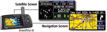
GPS Pictorial Representation
Global Positioning Systems for Defense
The U.S. department of defense maintains the GPS, whereby its main purpose is to aid military activities by its air force department. This department declared this system complete and operational in 1995, from the previously used initial operational capability (IOC). The defense department uses the PPS, which is a more reliable and protected system in its navigation operations (Dana p.1). In addition to reliability and security standards, PPS is very accurate in its timings and velocity, hence making it the best for military operations. This systems accuracy is almost 95% in determining exact locations, hence it can help to locate what the military wants or is timing, hence helping to formulate quick responses to security threats. PPS applies the cryptography technology to make sure, only individuals with authority access its information (Garmin p.1).
The defense department does not use the common receivers used by common civilians, but rather it uses an improved GPS receiver called the defense advanced GPS receiver (DAGR) for its local and foreign military operations. Engineers have designed this advanced receiver specifically for the military, because it has a double-frequency receiver. In addition, this system has an upgraded security hardware, which helps it to read encrypted codes in GPS signals. It is legally wrong for any individual to own this kind of receiver, unless legally registered by the National security Agency (NSA). In situations where such devices are obsolete, as dictated by NSA, organizations should return them to legally registered sellers. The agency uses these measures to ensure, it has total control on security of all U.S. citizens.
This gadget’s main features include a graphical screen with features that help it to overlap pictorial messages, a concurrent L1 or L2 with a double frequency receiver, high-speed performance capability in jammed conditions, and it can acquire directly the Y-code transmitted in media channels. In addition, this receiver has an integrated technology, which enables it to resist many effects resulting due to many channel overlap, and mechanisms of checking weapons. On the other hand, this gadget has mechanisms, which helps it to field the U.S. military and some specific international forces. Its design makes it more portable; hence, it can easily fit in all military dresses, specifically in the 2-magazine ammo porch (Rasmussen p.1).
Currently, due to changes in global crime more so changing patterns of terrorism, the U.S. air force has endeavored to improve the presently used GPS by introducing new features whose main aim is to create a more advanced satellite. In addition, these new features have helped to improve and sustain the currently available constellation. Some of improvements, which the Boeing in the recent past has introduced, include the launch and early orbit, disposal operations, operational control system (OCS), and the anomaly resolution (Boeing p. 1).
In addition, presently there is some ongoing collaboration between the European Union and some interested partners to make a new GPS; a project by Galileo, which they will have command over its operations. The new system is bound to change, the presently service GPS, whereby new propositions include introduction of a commercial service and a safety of life services (SoL), specially designed for security agents, and other authorized bodies (Defense Industry Daily para.2).
Conclusion
In conclusion, GPS is an important system, whose features are important tools for ensuring military operations succeed. This is because it helps to provide locations and exact positions of military personnel due to complexity in some military operations.
Works Cited
Boeing. Defense, Space and Security: Global Positioning System (GPS) IIF. Boeing. 2010. Web.
Dana, Peter. Global positioning systems overview. GPS. 1999. Web.
Defense Industry Daily. Galileo GPS project faces more certain future, 2010.Web.
Garmin. What is GPS? Garmin. 2010. Web.
Rasmussen, Theresa. Topographical engineering center: Defense Advanced Global Positioning System Receiver. Web.
U.S. Coast Guard Navigational Centre. Global positioning system: Serving the world. 2010. Web.